OVRDC Success
Carpenter Marty Transportation (CM) is included on the roster of consultants authorized to support the Ohio Valley Regional Development Commission (OVRDC) as needed. OVRDC engages these consultants through task orders that address specific transportation planning priorities identified by the commission and its member agencies. These assignments may include activities such as small-scale safety analyses, economic feasibility evaluations, complete streets planning, traffic counts, and traffic forecasting.
Our Experience with OVRDC-Funded Studies
CM has successfully delivered TWELVE transportation planning projects funded through this program.
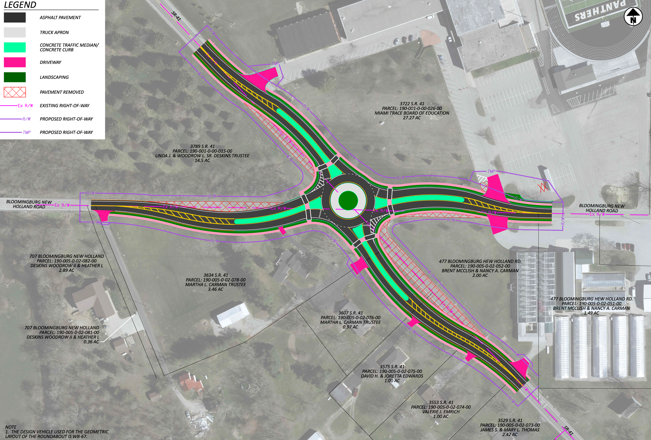
SR-41 & Bloomingburg New Holland Road Safety Study
CM conducted a safety study at the SR-41 and Bloomingburg-New Holland Road intersection in Fayette County, Ohio, aiming to reduce crash frequency and severity. Field observations, traffic counts, and crash data revealed a high number of injury-related angle crashes, emphasizing the need for safety improvements. Additional analyses included capacity, signal warrants, turn lane warrants, and sight distance evaluations for both current and future traffic conditions.
CM proposed a tiered set of countermeasures: short-term improvements such as enhanced signage and “Cross Traffic Does Not Stop” plaques; medium-term installation of warranted turn lanes; and a long-term solution. A roundabout was identified as the most effective measure for reducing angle crashes. Due to the intersection’s proximity to the Miami Trace Local School District, pedestrian infrastructure like sidewalks or a shared-use path was also recommended.
CM supported the County in securing ODOT HSIP funding for the roundabout, which was successfully obtained.
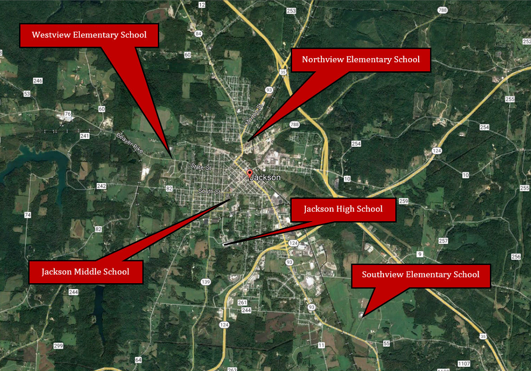
City of Jackson School Travel Plan
CM was retained by the OVRDC and the City of Jackson to develop a School Travel Plan (STP) for Jackson City schools. CM assisted the City of Jackson with the funding application which resulted in the City obtaining funding for the STP. The plan follows the guidelines and methodologies laid out by ODOT’s Safe Routes to School Program. Safe Routes to School (SRTS) is an international movement that uses programming and infrastructure to improve safety and encourage students to walk and bicycle to school. The project included evaluation of existing conditions, community engagement, development of infrastructure and non-infrastructure (programs and policies) recommendations, and a final report. The STP will be utilized by the City to seek funding for recommended countermeasures. The final deliverable is a full report inclusive of an exhibit and cost estimate for the highest priority project. The City benefits from this plan by having established framework for encouraging students to walk and bike to school safely and efficiently.

SCI-Portsmouth 17th Street Safety Study and Design
CM conducted a comprehensive safety study of 17th Street in Portsmouth, Ohio, spanning from Grandview Avenue to Mabert Road. The study aimed to identify conditions contributing to crashes, calm traffic, and enhance pedestrian safety in a corridor characterized by residential developments, high pedestrian activity, and limited traffic controls. CM performed field observations, demographic and crash data analysis, traffic counts, and capacity evaluations. Notably, the analysis revealed a high incidence of parked vehicle and pedestrian crashes—conditions exacerbated by inconsistent roadway widths, poor pavement markings, and a lack of designated pedestrian infrastructure.
To address these issues, CM proposed a range of short-, medium-, and long-term countermeasures. Recommendations included installing curb bump-outs, new pavement markings, Rectangular Rapid Flashing Beacons (RRFBs), speed limit signage, and reconfiguring several intersection controls. A mini roundabout was also recommended as a long-term solution at the 17th Street and Mabert Road intersection to improve traffic flow and safety. Cost estimates and benefit-cost analyses were prepared, and CM identified appropriate ODOT Highway Safety Improvement Program (HSIP) funding streams to support implementation. These recommendations provide a strategic framework for improving safety and mobility for all users along the corridor. The City successfully obtained funding for the recommended improvements and CM was selected to develop detailed design plans for the project.

Ross County Thoroughfare Plan Update
OVRDC and the Ross County Commissioner retained CM to complete an update of the Ross County Throughfare Plan. Previous Thoroughfare Plan updates were mostly completed in house with support provided by the Mid-Ohio Regional Planning Commission (MORPC), OVRDC, and the Ohio Department of Transportation (ODOT). Previous updates were primarily completed in-house with support from MORPC, OVRDC, and ODOT. The last comprehensive plan was finalized in 2008, with minor amendments in 2010 and 2012. Due to regional growth and completed priority projects, a 2021 update was needed to guide future infrastructure planning in Ross County and the City of Chillicothe.
Though minor, the update provides essential data to support future investment and prioritization. It includes demographic analysis, stakeholder and public input, updated maps, and an access management plan. CM collaborated with stakeholders to develop a 13-question public survey addressing transportation issues, proposed improvements, and growth trends. The survey received and summarized 66 responses.
As part of the update, CM produced several maps, including a Roadway Functional Classification Map, Annual Average Daily Traffic Map, and a Proposed Roadway Improvements Map.
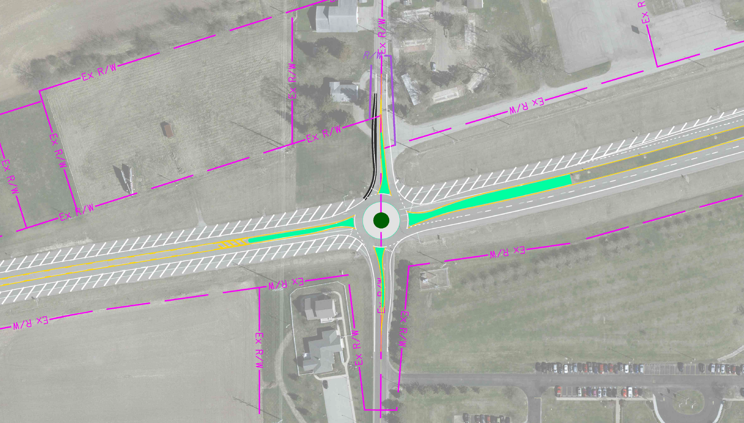
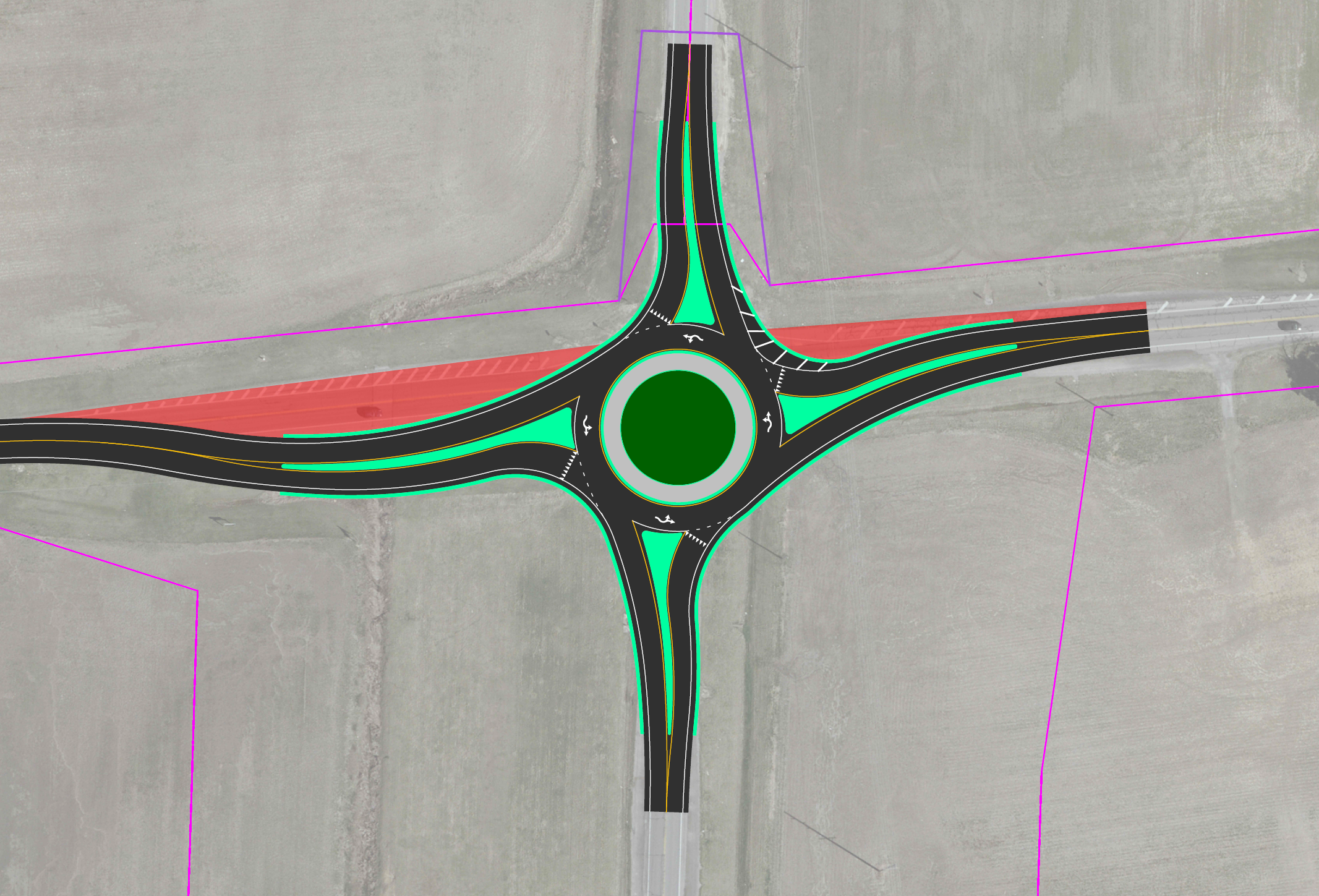
FAY-US 22 & Jamison Safety Study
CM conducted a comprehensive safety study of the intersection at US 22/SR 3 and CR 68 (Jamison Road) in Fayette County to assess existing conditions and identify countermeasures to reduce crash frequency and severity. The study evaluated roadway geometry, traffic volumes, crash patterns, and operational performance, revealing a high occurrence of angle crashes, including a fatality in 2018. CM developed and assessed both short- and long-term solutions, including turn lane restriping, access management, and geometric reconfigurations. Two long-term alternatives were considered: a Restricted Crossing U-Turn (RCUT) and a roundabout. The roundabout demonstrated a greater potential for crash reduction and improved traffic flow through lower vehicle speeds and simplified movements.
Based on the study findings, CM identified a roundabout with an associated road diet as the preferred alternative for the intersection. CM played a key role in assisting Fayette County in pursuing formal safety funding for the project. Ultimately, CM’s efforts culminated in successfully obtaining funding for the installation of the roundabout.
Rural Public Transit System Feasibility and Planning Study
CM’ s traffic team partnered with the local transit agency on a rural public transit feasibility and planning study for Highland County. The study focused on the City of Hillsboro, the Village of Greenfield, and the Rocky Fork Lake area. As a result, Highland County secured over $1 million in funding for a new 5311 Rural Transit Program.
CM reviewed existing transportation studies and ridership data from Highland County and nearby regions. A stakeholder group was formed, and meetings were held to gather input. Using StreetLight data, CM conducted an origin-destination study to identify major travel patterns, which were overlaid with census data on vehicle ownership, disabilities, and poverty to suggest potential routes and stops. A public survey was also developed and distributed in print and online to assess demand and define the desired system. CM received and analyzed over 150 responses.
CM aided in the 5311 funding application process. For this application, CM attended funding meetings with ODOT and the client as well as contacted agencies already running a 5311 transportation system to gather information on how they received funding.
CM’s recommendations following the study included the feasibility and sustainability of moving to, or adding, a 5311 transportation system. Potential planning-level routes were also analyzed and reviewed. This study was included as a part of the 5311 funding application delivered to ODOT Central Office. The project was awarded $1,117,215 for their new 5311 program.
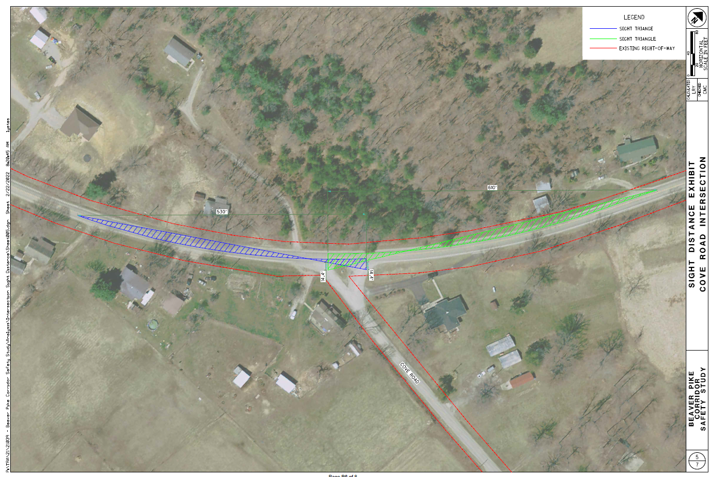
Beaver Pike Corridor Safety Study
Under the OVRDC Transportation Feasibility and/or Safety Study Master Service Agreement, Jackson County selected CM to conduct the Beaver Pike Corridor Safety Study. The study aims to assess current conditions and identify countermeasures to reduce crash frequency and severity along Beaver Pike, from the county’s western limits to Cherry Avenue, including intersections.
CM analyzed intersection sight distances and evaluated existing passing zones. Crash data (2010–2020) was sourced from ODOT TIMS, yielding 164 crashes. OH-1 reports were reviewed to create crash diagrams. Using ODOT ECAT and the Highway Safety Manual’s predictive method for rural two-lane roads, CM assessed the corridor’s potential for safety improvements.
Recommended short- and long-term countermeasures included revising passing zones, adding raised pavement markers, signage, guardrails, rumble strips, clearing vegetation, and reconfiguring intersections. CM also developed concept plans, cost estimates, and benefit-cost analyses for the proposed improvements.
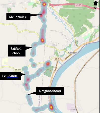
Gallipolis Local Bypass Safety & Feasibility Study
OVRDC and the Gallia County Engineer are proposing a safety and feasibility study for the Gallipolis local bypass, which connects SR-160 and SR-218, and indirectly US-35 and SR-7, via local roads that avoid the central business district. Potential bypass routes include McCormick Road, Safford School Road, and Neighborhood Road.
The study will assess existing roadway segments and intersections along the bypass, providing recommendations to enhance safety, mobility, connectivity, and infrastructure. Based on the proposed fee, this will be a planning-level study using available data to deliver general recommendations. Tasks like turning movement counts were excluded to prioritize higher-impact items within budget. The scope can be revised if more detailed data or analysis is needed.
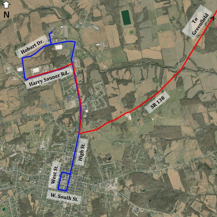
Hillsboro Traffic Analysis
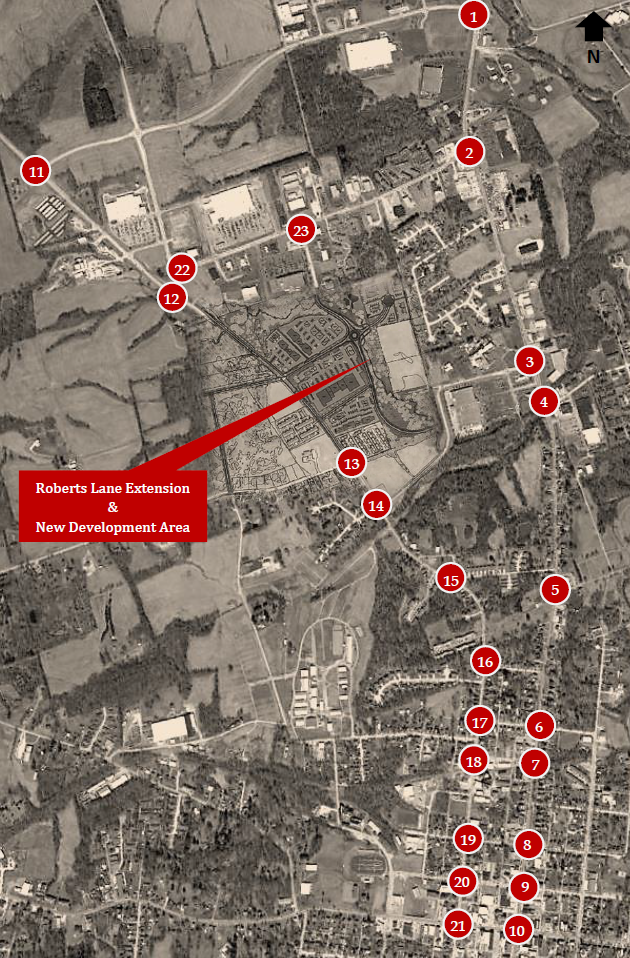
Through an OVRDC-funded contract, CM conducted a comprehensive traffic analysis for the City of Hillsboro to assess the impact of projected development and infrastructure changes through 2045. The study evaluated existing conditions and two future scenarios: Scenario 1, which includes the Roberts Lane extension and new development, and Scenario 2, which adds one-way conversions of N. West Street and N. High Street.
CM used 2022 StreetLight origin-destination data and ODOT growth rates to project traffic volumes. Development-generated trips were estimated using ITE trip generation rates and distributed across 23 study intersections. Turn lane and signal warrants, as well as capacity analyses, were performed using Synchro 11.
Both scenarios showed impacts, but Scenario 1 was recommended due to its lower infrastructure complexity and better support for pedestrian and cyclist mobility. Scenario 2 would require more extensive upgrades and could conflict with active transportation goals. CM recommended Scenario 1 and suggested the City adopt formal Traffic Impact Study standards to guide future development planning.
FAY-US 22 & SR-753 Safety Study
CM conducted a comprehensive safety study at the US-22 and SR-753 intersection in Fayette County, Ohio, to address ongoing crash issues. Identified as a priority by the Fayette County Engineer’s Office, the site, just east of Washington Court House, was analyzed for traffic volumes, crash patterns, and roadway geometry. Despite prior short-term upgrades (e.g., LED stop signs and warning signage), crash data showed a high rate of angle (71.1%) and rear-end collisions.
CM recommended a long-term solution: a single-lane roundabout. A full capacity analysis confirmed the roundabout would maintain acceptable delay and service levels through 2045 while significantly reducing conflict points. A benefit-cost analysis using ODOT’s ECAT tool showed a strong return on investment. Based on these results and the proven safety performance of roundabouts, CM advised moving forward with implementation and is currently assisting the County in securing ODOT HSIP funding for construction.
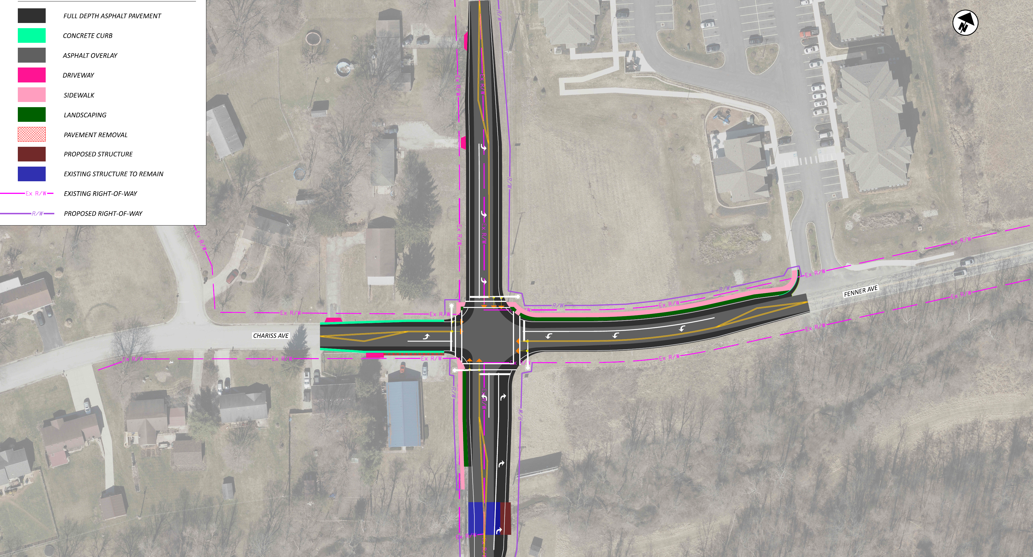
SR-73 & Chariss Avenue/Fenner Avenue
CM completed a comprehensive safety and capacity study for the intersection of SR-73 and Chariss Avenue/Fenner Avenue in Hillsboro, Ohio. The study was initiated in response to anticipated growth along the Roberts Lane and SR-73 corridor, including multiple commercial and residential developments. CM conducted detailed traffic volume projections, crash analysis, and field assessments to evaluate current and future operational needs. CM reviewed previous planning efforts, incorporated updated development data, and identified a significant increase in rear-end crashes—especially on the southbound approach—likely due to poor signal visibility, vertical curvature, and increased traffic pressure in the area.
Based on the findings, CM recommended several countermeasures, including replacing outdated “Prepare to Stop When Flashing” signs with radar detection, upgrading the traffic signal, and installing dedicated turn lanes. These improvements are expected to address both operational delays and the high frequency of rear-end collisions. CM also assisted the City in applying for ODOT Small City Funding to support implementation of the recommended improvements. While the application was ultimately not selected, the City is well-positioned for future funding opportunities.
Ross County Rural Transit Feasibility Study
OVRDC and the City of Chillicothe retained CM to complete the Ross County Rural Transit Feasibility Study. This study is currently underway. A stakeholder group was formed to assess the need for county-to-city transportation, and a public survey, developed with stakeholder input,was distributed, analyzed, and summarized by CM to inform the study.
Demographic data from census and StreetLight sources is being used to evaluate income, poverty, family status, education, age, health, disability, and commuting methods. An origin-destination study using StreetLight data will identify major travel patterns, which will be cross-referenced with census data on vehicle ownership, disabilities, and poverty to highlight potential transit needs.
CM will estimate the planning-level economic impact of improved access to the City for workers and consumers. Planning-level transit solutions and costs will be developed to meet identified needs. The study will align with the Coordinated Plan’s goals and guide next steps for the Chillicothe Transit System and partner agencies. The final report will include background, data, analysis, stakeholder input, conclusions, and recommendations.